info@fiskerforum.com +45 60 22 09 46

Facebook Instagram Youtube Twitter Envelope
  • Dansk
Logo-FiskerForum
  • News
    • Latest News
    • Newbuildings
    • News Categories
      • News
      • Accidents – Shipwreck
      • Administration
      • Aquaculture
      • Associations
      • Economy
      • Education
      • End User – Food
      • Environment
      • Exhibitions
      • Fish Species
      • Fishing
      • Manufacturers
      • Story
      • Politics
      • Ports
      • Products
      • Regions
      • Research
      • Sponsored
      • Videos
    • News Service
    • News Archive
      • 2026
      • 2025
      • 2024
      • 2023
      • 2022
      • 2021
      • 2020
      • 2019
      • 2018
      • 2017
      • 2016
      • 2015
      • 2014
      • 2013
      • 2012
      • 2011
      • 2010
  • Vessels
    • Vessels
    • Recent Photos
    • Newbuild
    • Newbuild delivered
  • Service
    • Contact
    • Oil Prices
    • Auction Prices
    • Weather
    • News Service
    • Media Information
  • Industry Directory
  • Recent photos
A group of Norwegian fishing vessels is testing Maroeano charts at sea. Image: MAREANO - @ Fiskerforum

Fishing vessels try out Mareano charts

  • August 10, 2018
  • FiskerForum
  • Dato: 10/08/2018
  • kl. 00:00
  • Kategori: Products
  • Tags: Electronics
  • Land: Norway
Hook&Net - Hook and Net is a trade journal for the international commercial fishing industry,
Skal din annonce være her - ring til os !
Polar Expo 2026
Scottish Skipper-Expo 2026
Trusted energy partner for the maritime industry

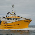
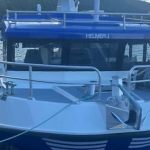
Seventeen fishing vessels from seven Norwegian fishing companies are currently trying out Mareano charts on their chart plotters. These show undersea terrain and bottom types produced using advanced multi-beam echo sounders.

‘These charts are available in a variety of formats that can be used in the most common chart plotters,’ said Hanne Hodnesdal, the Mapping Authority’s representative in the executive group.

Testing began last year, when the charts were supplied to thirteen fishing vessels, and this is now it has increased to seventeen vessels.

‘We are now waiting for feedback from the fishing vessels testing this new tool,’ said Frithjof Moy of the Marine Research Institute, who heads Mareano’s executive group.

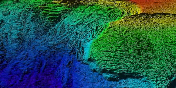
The Mareano charts are produced using data from advanced multi-beam echo soundings to provide highly detailed seabed imagery. However, the most detailed charting is reserved for areas beyond Norwegian territorial waters.

‘The Norwegian Armed Forces has classified information about the seabed off Norway. This means that we must degrade the data quality of the terrain in coastal areas,’ explained Hanne Hodnesdal.

In addition to the terrain cartography, a seabed map is also made showing what the bottom consists of. This information is not classified.

‘The bottom maps are based on seabed reflection data from multi-beam sources, seabed samples and video observations, providing as detailed information on the nature of the seabed both within and outside the territorial boundary,’ said Lilja R. Bjarnadóttir of the Norwegian Geological Survey.

Mareano maps depth and topography, sediment composition, biodiversity, habitats and biotopes as well as pollution in the seabed in Norwegian offshore areas. The programme’s aim is to provide answers to questions such as:

• How is the seascape of the Norwegian continental shelf?

• What does the seabed consist of?

• How is the biodiversity distributed on the seabed?

• How are habitats and biotopes distributed on the seabed?

• What is the relationship between the physical environment, biodiversity and biological resources?

• How much contaminants are stored in the bottom sediments?

‘We publish data collected through Mareano on mareano.no and geonorge.no as they are quality assured,’ Frithjof Moy added.

Mareano’s pages can be used to view charts, or to compile their own. Other data from Mareano can also be downloaded from various data owners, with links to these partners on Mareano’s page.

The Institute of Marine Research, the Geological Survey of Norway and the Norwegian Mapping Authority comprise the Executive Group which is responsible for carrying out the Mareano field sampling and other scientific activities. The Programme Group, led by the Norwegian Environment Agency, has the executive responsibility for the Mareano activities.

The programme is financed by the Ministry of Trade, Industry and Fisheries, and the Ministry of Climate and Environment. These ministries, inclusive of the ministries of Petroleum and Energy, Local government and Modernisation and the Ministry of Transport and Communications, form the Mareano steering board.

Besøg os på
Seneste Nybygninger

Crabber ready for handover

Latest Altaire joins Shetland fleet

Macduff delivers Fraserburgh twin-rigger

New Cleopatra 36 for Lofoten fisherman

PrevForrige nyhedFishing and food companies aim to merge
Næste nyhedIceland plans new marine research vesselNext

Minister aspires to opening a real path to transition

Outlining shocks to the European seafood sector

Beefed-up Flow Gear performs well on Icelandic rough ground

Billion-Euro trawl study’s claims based on discredited science

ANNONCER

Cosmos Trawl
Vonin - We make the ocean more profitable
SIMRAD SY50 FiskerForum
Thyborøn Havn er en spydspids på vestkysten.  Foto: Thyborøn Havn er en vækstmotor for det lokale erhvervsliv - Thyborøn Havn
Atlantic Shipping

ADS

Contact info

  • +45 60 22 09 46
  • info@fiskerforum.com
  • Otto Pedersvej 1
    6960 Hvide Sande
    Denmark

News

  • Latest News
  • Newbuildings
  • News Service
  • Know anything?
  • News in Danish

Service

  • Vessels
  • Classifieds (coming)
  • Jobs (coming)
  • Oil Prices
  • Auction Prices
  • Media Information

News Archive

  • 2019
  • 2018
  • 2017
  • 2016
  • 2015

News Service

Facebook-f Twitter Youtube
Logo-FiskerForum

All pictures, texts and data on FiskerForum are protected by Danish copyright law. All rights belong or are handled by FiskerForum.com on behalf of the associated photographers. It is not allowed to copy or use texts, data or pictures from FiskerForum without permission. © 2004 - 2019

Made with love by ApolloMedia

Terms and conditions Cookie & Privacy Policy